Finding it hard to decide what to wear? Do you always wear too many or too few layers of clothing? This app is the solution!
With funny clipart and a smart weather formula, this app recommends the ideal clothing composition. This includes for example how many layers of clothes you should wear when it's cold and it reminds you to take your sunglasses with you when it's hot and sunny.
There is also a great share function to let your friends know ...Morehow hot or cold it is and what you should wear at your city!
Terrafin has provided key satellite data online for anglers, divers, and researchers since 1998. Now, Terrafin Mobile gives subscribers easy access to this data from your iPhone or iPad.
Note: The Terrafin Mobile app installs with an assortment of sample charts, that you can use to try the various features. Access to current data requires an active subscription to the Terrafin website, available @ $109.99/year.
Terrafin Mobile Features:
...More• Browse Terrafin website to easily select charts. • Charts are downloaded to device for use offline. • Tap and drag cursor for accurate positioning. • Latitude / Longitude / Temperature readings at cursor. • Mark waypoints. • Distance & Bearing to waypoint or cursor. • Real time vessel location and track displayed on chart (GPS enabled device required).
Data available with Terrafin Mobile
• Hi Res (1.1km) Sea Surface Temperature Charts, updated 2-3x daily. • Hi Res (1.1km) Chlorophyll / Ocean Color Charts, updated daily. • Altimetry (Sea Surface Height) Charts, updated daily. • Geostrophic Currents Charts, updated daily. • CloudFree SST charts, updated daily.
Areas of Coverage:
• U.S. East, West, and Gulf Coasts • Alaska & Hawaii • Caribbean & Bermuda • Mexico, including Baja and Sea of Cortez • Central America (Pacific Coast) • Venezuela • Brazil • Australia East Coast
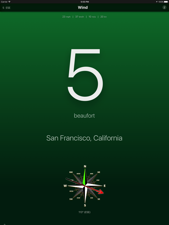
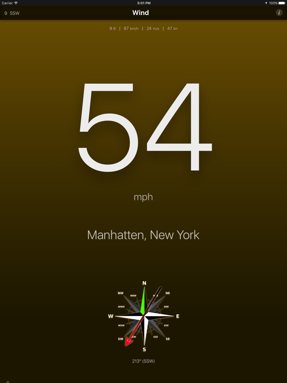
High quality and simple to use application that shows wind speed and direction anywhere in the world. Want to know how windy it is outside without having to run out there? So this app is for you!
Simple, quick, effective. Get the useful information with one touch! • Browse Terrafin website to easily select charts. • Charts are downloaded to device for use offline. • Tap and drag cursor for accurate positioning. • Latitude / Longitude / Temperature readings at cursor. • Mark waypoints. • Distance & Bearing to waypoint or cursor. • Real time vessel location and track displayed on chart (GPS enabled device required).
Data available with Terrafin Mobile
• Hi Res (1.1km) Sea Surface Temperature Charts, updated 2-3x daily. • Hi Res (1.1km) Chlorophyll / Ocean Color Charts, updated daily. • Altimetry (Sea Surface Height) Charts, updated daily. • Geostrophic Currents Charts, updated daily. • CloudFree SST charts, updated daily.
Areas of Coverage:
• U.S. East, West, and Gulf Coasts • Alaska & Hawaii • Caribbean & Bermuda • Mexico, including Baja and Sea of Cortez • Central America (Pacific Coast) • Venezuela • Brazil • Australia East Coast
Online shopping for the latest electronics, fashion, phone accessories, computer electronics, toys, garden, home appliances, tools, home improvement and more.
Weather Concierge's new app is called MicroBurst. It is a new, interactive weather forecasting application pioneering the way businesses and people consume weather information. Our mission is to provide weather the way you want it, and be the Calm Before… During…and After the Storm.
We offer 100+ years of experienced forecasting, which is highly accurate, hyper-local, non-hyped, and very personalized. Unlike traditional weather ...Moreproviders, Weather Concierge offers context and answers to users on a deeper level. We go beyond mere localization and personalization by forging customized relationships with our audience. We do this by offering our followers the ability to directly interact with our meteorologists, providing a richer, more experiential forecast.
Do you want to go sailing, windsurfing, biking or just out of the door? This application shows the current local outdoor wind speed (in beaufort, mph and km/h) and direction, measured by a nearby weather station for which it uses your current location.
Features: - The background color changes with the wind speed - The direction of the wind is shown on a live compass - Change between different wind speed units (beaufort, mph, km/h, m/s, knots) - ...More Change arrow poining direction to either from wind or to wind (weather vane) - The wind is automatically updated every hour - The location is automatically updated when you move more than 5 miles/10km - The current wind date can be shared - Support for iPhone X - Support for the iPad multitasking (split view..)
Get information about this global phenomena as well as participate (as a volunteer) in capturing the data we need to better understand and solve the challenges it brings.
You can:
• Participate in crowd-sourcing events to capture the data researchers and civic leaders require but lack • Find nearby "Trouble" spots that affect your travel during times of inclement weather... and join in by adding spots you find troubling so ...Morewe grow the collective dataset • Take photos to document what's occurring in your region and share them with friends or through Facebook • Access semi-private collaboration spaces called regions where you can manage volunteers and schedule mapping events
Sea Level Rise 2.0 is a major update which allows anyone in the world to begin mapping sea level rise! We started in Hampton Roads, Virginia and have learned from the mapping efforts of 1,000s of volunteers. In this updated release you can start a regional group, schedule your own mapping events, and use GPS tools to contribute data points for weather and tide events.
Virtually everyone in and around a low-lying coastal region is or will be affected by sea level rise. This app moves us in the direction of being a better informed and connected community so we can do something about it.
So if it's only information you seek, download it. But if you're looking for a way to get further involved, this app is really for you.